San Joaquin River Trail part I
Click on photos to see larger versions.
 Did you know that a single trail exists that will eventually allow hikers to travel from highway 99 in West Fresno to the East side of the Sierras? How about that there's a quiet 14 mile long trail that is just beyond Table Mountain Casino, only about 45 minutes from central Fresno? If not, then I should tell you about the San Joaquin River Trail (SJRT).

The San Joaquin River trail right now is a collection of historical and modern trail segments that roughly follow the San Joaquin River and the route of Native Americans and later miners as they crossed the Sierras. In some places the trail is a maintained foot path, in others a jeep trail. In a few places it disappears altogether. The longest complete segment in the foothills connects the terminus of Sky Harbor Road to the BLM's San Joaquin River Gorge (formerly known as Squaw Leap) near Auberry. If you read the Weekend section of Friday's (March 3rd) Fresno Bee you probably noticed a front page article about a trail at the San Joaquin River Gorge. The main trail in that article is a different trail known as the Loop. But it begins at the same trailhead as the SJRT. And the SJRT is mentioned as 'a 14-mile hike'. While the SJRT heads downstream parallel to and far above the river, the Loop Trail heads down to a pedestrian bridge crossing, over the river before it splits into two uphill trails that form a loop. Both trails have significant up-and-down exercise. Right now I'll focus on the SJRT as I just completed a short 6 mile hike along its course a couple of weeks ago. In some places you will hear of the SJRT as a 76-mile trail from Friant Dam to Devil's Postpile National Monument in the Eastern Sierras. But the San Joaquin River Parkway Trust and other organizations plan to extend the route to Highway 99. How long will that take? 20 years? I don't know.Several follow-ups on this topic are in the works as I have had a number of experiences on various segments of this trail.
February 12, 2006.
I'm so used to seeing smog in Fresno and even in the foothills that I didn't think too much of the grey layer of air hanging over Millerton Lake at noon. I chose to hike the down the San Joaquin River Trail because it's close and I thought I could do some fishing for (spotted?) bass that seem to be active in the ripples of narrower sections of the river canyon. Fishing in small streams of the Sierras doesn't open until April.
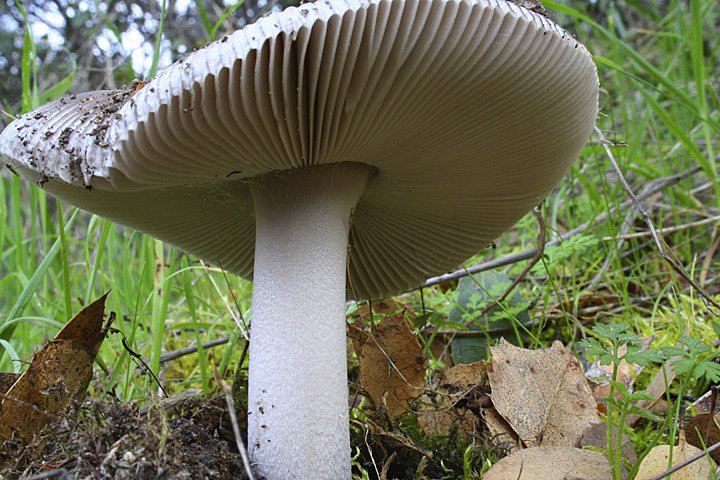
The cows at the entrance gate to the trail were all heifers so I wasn't too put off by their presence. The first thing I noticed different about the trail on this hike was a lot of new flagging dedicated to trail maintenance plans. That's a good sign. The maintenance of trails around Millerton has often been overlooked, and can sometimes lead to dangerous trail conditions. The beginning of the trail can be misleading. The first section is uphill which seems like the wrong way considering the trail leads downstream along the river. But eventually the slope heads back down and steeply at times. I was hoping to see some active wildlife such as Turkeys (not native) but the real points of interest turned out to the be small things that usually escape notice, like the new mushrooms, the new leafs budding out on the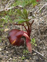 oaks and the brightly colored lichen on granite rocks. And the coolest thing I saw was the germinating buckeye nut (below left).
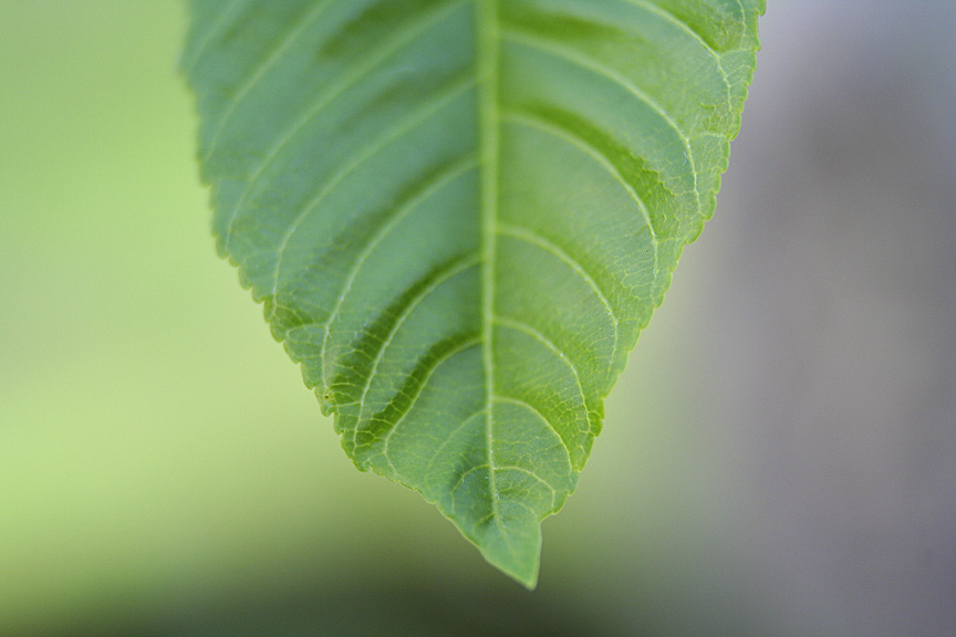
The buckeye leaves are already well developed (see above right) as they are usually the first to bud out. They are also the first to fall in the summer while other trees are busily carrying out photosynthesis. Last year's nuts have started to sprout and give children (or adults) a good look at seed germination in action due to their size. The shoot first reaches the ground and then splits somewhere between the nut and the ground where the first leaves push skyward. The tree starts forming while still connected by the umbilical-like connection. I collected a few nuts that had just started to sprout from the sand below the high water line of the river. Those trees weren't going to make it anyway so I didn't feel too bad about taking a few home to try growing in the yard. So far they have survived in a planter but don't appear as healthy as they were in situ.
I like to pick up a few buckeye nuts during the fall before they sprout too because they have a very smooth seed cover once they come out of their leathery outer cover. A buckeye makes a perfect 'worry stone' (other than the fact it isn't a stone). You can keep one in your pocket and rub the tough smooth cover when you're anxious. I'm not into new age philosophy but I find that using a worry stone does have a therapuetic quality like rocking in a rocking chair, swinging in a hammock or floating in a boat. They're also pretty to look at but they tend to shrivel after being kept in a dry environment for a few months.
The one thing you don't want to do with a buckeye nut is eat it. According to everything I've read on the subject they are toxic. Native peoples used mashed up seeds in streams to stun fish but they would only eat buckeye themselves after repititive leaching as with oak acorns. So while they may provide a great science lesson for kids, don't leave the nuts where children can grab them.

There are some interesting man-made items to be found along the river as well. You can find anything from the usual bass lures and driftwood to toys, construction tools and cut lumber. As disappointing as it can be to see trash on a hike, you can find some great subjects for found art out there if that's your thing.
 About two miles in on the trail there is a must-see natural feature. As you approach this point on the trail you will sometimes hear a waterfall like sound or feel the temperature drop depending on the time of year. The cool air and rushing water sound are the product of a 'cave' that may have been formed by the drilling action of rocks spun by water pressure. It's a narrow slot canyon shaped cave. This time of year cold water rushes through, creating air displacement. Later in the Summer and Fall the water flow drops enough that an adventurous spirit may climb upstream to explore the cave further. In the Winter and Spring the water flow causes the rock surfaces to be extremely slippery. A few openings above allow shafts of light to descend and make for tricky contrasts for photography. Though it's just a few feet undergrou
 nd, the rush of the water and the dark cool air make me feel like I'm in a different world where I might find some creature new to science.
I came down to the water's edge to see about fishing but there were two large log flotillas. I'm not sure if you could call them log 'jams' as they weren't jammed into the space between the rocky shores and they only appeared to be on the surface. In fact as I sat and watched the lower log flotilla it continued to move upstream at about 1-2 mph probably on account of wind. Boats were kept from moving upstream even though the current water level would normally allow passage further. I tried fishing for a few minutes but it seemed like a dead day on the river. Besides I had so much fun stopping to photograph mushrooms, buckeyes and the cave that I had left no time to fish! So I made the steep hike back uphill to the trailhead parking lot.
 The smog/haze was so thick it was like a dirty grey fog upcanyon. The smog can actually make for good sunsets photographs (as long as your subject isn't far away) so I stopped to take a few. But for the very first time in central California I actually could feel the bad air quality in my throat and chest after hiking uphill. I've had that feeling before when hiking near Los Angeles, like I could't breathe in all the way or a horrible pain would hit me below the throat. It was a sobering realization that the air quality in the Fresno area can really take me down a notch.
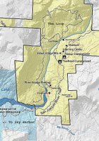
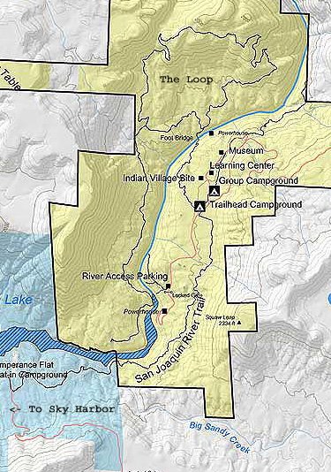
I'll be sure to add more information about the San Joaquin River Trail as I move further back and forward through the timeline of my hikes in the Sierras. If you want to visit it yourself you can click on the map (above left) to see where the trailhead is located in relation to the several trails in the area. Or you can go the Millerton State Recreation Area map, which shows the entire 14 mile segment. To get there take Friant Road past Millerton Lake where it turns into Millerton Road and past the Table Mountain Casino. Take a left on Auberry Road and drive through the town of Auberry. When you reach a fork in the road above the school at the end of town you should take a left again. Now you will be on Powerhouse Road as you pass a trailer park. Eventually you will have to take a hard right on to Smalley Road where there is a BLM sign for the San Joaquin River Gorge. Follow that down to the trailhead campground and park.
All photos for this post were taken with a Canon Digital Rebel XT camera.
 Did you know that a single trail exists that will eventually allow hikers to travel from highway 99 in West Fresno to the East side of the Sierras? How about that there's a quiet 14 mile long trail that is just beyond Table Mountain Casino, only about 45 minutes from central Fresno? If not, then I should tell you about the San Joaquin River Trail (SJRT).
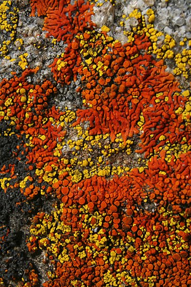
The San Joaquin River trail right now is a collection of historical and modern trail segments that roughly follow the San Joaquin River and the route of Native Americans and later miners as they crossed the Sierras. In some places the trail is a maintained foot path, in others a jeep trail. In a few places it disappears altogether. The longest complete segment in the foothills connects the terminus of Sky Harbor Road to the BLM's San Joaquin River Gorge (formerly known as Squaw Leap) near Auberry. If you read the Weekend section of Friday's (March 3rd) Fresno Bee you probably noticed a front page article about a trail at the San Joaquin River Gorge. The main trail in that article is a different trail known as the Loop. But it begins at the same trailhead as the SJRT. And the SJRT is mentioned as 'a 14-mile hike'. While the SJRT heads downstream parallel to and far above the river, the Loop Trail heads down to a pedestrian bridge crossing, over the river before it splits into two uphill trails that form a loop. Both trails have significant up-and-down
 exercise. Right now I'll focus on the SJRT as I just completed a short 6 mile hike along its course a couple of weeks ago. In some places you will hear of the SJRT as a 76-mile trail from Friant Dam to Devil's Postpile National Monument in the Eastern Sierras. But the San Joaquin River Parkway Trust and other organizations plan to extend the route to Highway 99. How long will that take? 20 years? I don't know.Several follow-ups on this topic are in the works as I have had a number of experiences on various segments of this trail.
February 12, 2006.
I'm so used to seeing smog in Fresno and even in the foothills that I didn't think too much of the grey layer of air hanging over Millerton Lake at noon. I chose to hike the down the San Joaquin River Trail because it's close and I thought I could do some fishing for (spotted?) bass that seem to be active in the ripples of narrower sections of the river canyon. Fishing in small streams of the Sierras doesn't open until April.

The cows at the entrance gate to the trail were all heifers so I wasn't too put off by their presence. The first thing I noticed different about the trail on this hike was a lot of new flagging dedicated to trail maintenance plans. That's a good sign. The maintenance of trails around Millerton has often been overlooked, and can sometimes lead to dangerous trail conditions. The beginning of the trail can be misleading. The first section is uphill which seems like the wrong way considering the trail leads downstream along the river. But eventually the slope heads back down and steeply at times. I was hoping to see some active wildlife such as Turkeys (not native) but the real points of interest turned out to the be small things that usually escape notice, like the new mushrooms, the new leafs budding out on the
 oaks and the brightly colored lichen on granite rocks. And the coolest thing I saw was the germinating buckeye nut (below left).
The buckeye leaves are already well developed (see above right) as they are usually the first to bud out. They are also the first to fall in the summer while other trees are busily carrying out photosynthesis. Last year's nuts have started to sprout and give children (or adults) a good look at seed germination in action due to their size. The shoot first reaches the ground and then splits somewhere between the nut and the ground where the first leaves push skyward. The tree starts forming while still connected by the umbilical-like connection. I collected a few nuts that had just started to sprout from the sand below the high water line of the river. Those trees weren't going to make it anyway so I didn't feel too
 bad about taking a few home to try growing in the yard. So far they have survived in a planter but don't appear as healthy as they were in situ.
I like to pick up a few buckeye nuts during the fall before they sprout too because they have a very smooth seed cover once they come out of their leathery outer cover. A buckeye makes a perfect 'worry stone' (other than the fact it isn't a stone). You can keep one in your pocket and rub the tough smooth cover when you're anxious. I'm not into new age
 philosophy but I find that using a worry stone does have a therapuetic quality like rocking in a rocking chair, swinging in a hammock or floating in a boat. They're also pretty to look at but they tend to shrivel after being kept in a dry environment for a few months.
The one thing you don't want to do with a buckeye nut is eat it. According to everything I've read on the subject they are toxic. Native peoples used mashed up seeds in streams to stun fish but they would only eat buckeye themselves after repititive leaching as with oak acorns. So while they may provide a great science lesson for kids, don't leave the nuts where children can grab them.

There are some interesting man-made items to be found along the river as well. You can find anything from the usual bass lures and driftwood to toys, construction tools and cut lumber. As disappointing as it can be to see trash on a hike, you can find some great subjects for found art out there if that's your thing.
 About two miles in on the trail there is a must-see natural feature. As you approach this point on the trail you will sometimes hear a waterfall like sound or feel the temperature drop depending on the time of year. The cool air and rushing water sound are the product of a 'cave' that may have been formed by the drilling action of rocks spun by water pressure. It's a narrow slot canyon shaped cave. This time of year cold water rushes through, creating air displacement. Later in the Summer and Fall the water flow drops enough that an adventurous spirit may climb upstream to explore the cave further. In the Winter and Spring the water flow causes the rock surfaces to be extremely slippery. A few openings above allow shafts of light to descend and make for tricky contrasts for photography. Though it's just a few feet undergrou
 nd, the rush of the water and the dark cool air make me feel like I'm in a different world where I might find some creature new to science.
I came down to the water's edge to see about fishing but there were two large log flotillas. I'm not sure if you could call them log 'jams' as they weren't jammed into the space between the rocky shores and they only appeared to be on the surface. In fact as I sat and watched the lower log flotilla it continued to move upstream at about 1-2 mph probably on account of wind. Boats were kept from moving upstream even though the current water level would normally allow passage further. I tried fishing for a few minutes but it seemed like a dead day on the river. Besides I had so much fun stopping to photograph mushrooms, buckeyes and the cave that I had left no time to fish! So I made the steep hike back uphill to the trailhead parking lot.
 The smog/haze was so thick it was like a dirty grey fog upcanyon. The smog can actually make for good sunsets photographs (as long as your subject isn't far away) so I stopped to take a few. But for the very first time in central California I actually could feel the bad air quality in my throat and chest after hiking uphill. I've had that feeling before when hiking near Los Angeles, like I could't breathe in all the way or a horrible pain would hit me below the throat. It was a sobering realization that the air quality in the Fresno area can really take me down a notch.
I'll be sure to add more information about the San Joaquin River Trail as I move further back and forward through the timeline of my hikes in the Sierras. If you want to visit it yourself you can click on the map (above left) to see where the trailhead is located in relation to the several trails in the
 area. Or you can go the Millerton State Recreation Area map, which shows the entire 14 mile segment. To get there take Friant Road past Millerton Lake where it turns into Millerton Road and past the Table Mountain Casino. Take a left on Auberry Road and drive through the town of Auberry. When you reach a fork in the road above the school at the end of town you should take a left again. Now you will be on Powerhouse Road as you pass a trailer park. Eventually you will have to take a hard right on to Smalley Road where there is a BLM sign for the San Joaquin River Gorge. Follow that down to the trailhead campground and park.
All photos for this post were taken with a Canon Digital Rebel XT camera.
posted by -j- at 10:36 AM
![]()
![]()

4 Comments:
Good hike description!! that said, remember you are in the SIERRA, not Sierras....there is only one (therefore Singular noun) Sierra Nevada mountain range in California.
Great hike descriptionand pix!! That said, there is only one Sierra, never, never Sierras!
S.
Light use on the River Trail last Saturday in June. Saw one bike and one runner in 15 miles out and back from the Gorge area on Smalley Rd. It goes through Kerchoff PG&E area and Temperance Flat proposed dam site. Access links are Wellbarn Rd. to the south. The rock jumble where the creek echoes underground is cool.
you said that they were planning on connecting the sky harbor trail to devils postpile for a 78 mile hike. Have they done this? I'm an avid long-distance backpacker (thru-hiker) I'd love to do a little out and back trip. If the trail isn't connected is it possible to cross-country? Or is it on private land?
Post a Comment
<< Home